Geophysical-morphometric interpretation in support of the geological mapping of sheet 3885-II, Matanzas, Cuba
Article Sidebar
Main Article Content
Abstract
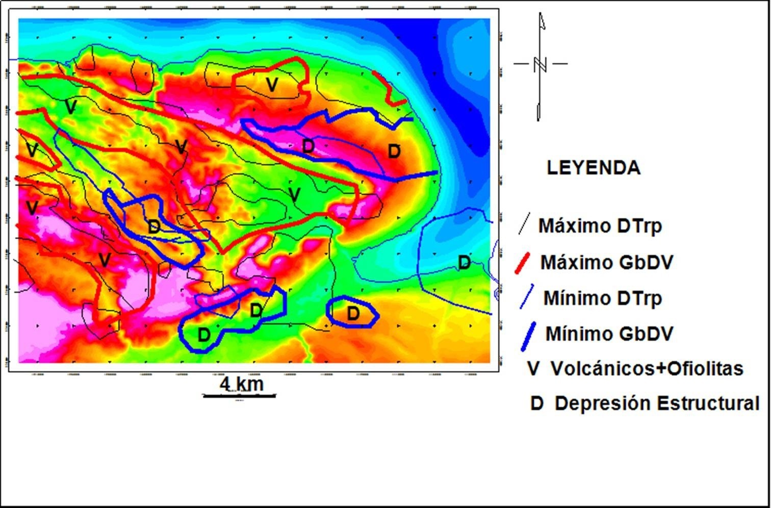
As a rule, field geological observations supplemented by remote sensing information are insufficient for the purposes of subsurface geological mapping of a territory, particularly when its structural framework is very complex. In these cases, the assistance of geophysical-morphometric interpretation is essential. In this sense, it is known that potential fields help in the structural-tectonic deciphering of the territory and, to a lesser extent, in the lithological mapping of the different geological units present, with the inverse contribution of airborne gamma spectrometry. The objective of the research was to support the geological mapping of the area with an integrated geophysical-morphometric interpretation. The materials used were: gravimetric and aeromagnetic field grids at scales of 1:50 000 and airborne gamma spectrometry at scale of 1:100 000 of the Republic of Cuba; Digital Elevation Model (90x90 m) of the Republic of Cuba and Digital Geological Map at a scale of 1: 100 000 of the Republic of Cuba. The methods used were gravimetry; aeromagnetometry; non-conventional morphometry and aerial gamma spectrometry. As a result of the investigation, the subsurface geological structure (~ 500 m) of the territory was mapped from the integrated gravi-magnetic and morphometric interpretation. In addition, the surface lithological composition was established and mapped from the radioactive nature of the residual soils. Thus, the following are recognized: structural depressions, tectonic limits, a possible uplift of rocks of the North American Continental Margin, presence of volcanic + ophiolites with a depressed macro structure and the presence of rocks with potassium feldspar contents, clays, carbonates with phosphatization and serpentinites.
Article Details

This work is licensed under a Creative Commons Attribution-NonCommercial 4.0 International License.
Those authors who have publications with this journal accept the following terms of the License Attribution-NonCommercial 4.0 International (CC BY-NC 4.0):
You are free to:
- Share — copy and redistribute the material in any medium or format
- Adapt — remix, transform, and build upon the material
The licensor cannot revoke these freedoms as long as you follow the license terms.
Under the following terms:
- Attribution — You must give appropriate credit, provide a link to the license, and indicate if changes were made. You may do so in any reasonable manner, but not in any way that suggests the licensor endorses you or your use.
- NonCommercial — You may not use the material for commercial purposes.
- No additional restrictions — You may not apply legal terms or technological measures that legally restrict others from doing anything the license permits.
The journal is not responsible for the opinions and concepts expressed in the works, they are the sole responsibility of the authors. The Editor, with the assistance of the Editorial Committee, reserves the right to suggest or request advisable or necessary modifications. They are accepted to publish original scientific papers, research results of interest that have not been published or sent to another journal for the same purpose.
The mention of trademarks of equipment, instruments or specific materials is for identification purposes, and there is no promotional commitment in relation to them, neither by the authors nor by the publisher.
How to Cite
References
Colectivo de Autores (2010): Mapa Geológico Digital de la República de Cuba a escala 1:100 000. Inédito. Instituto de Geología y Paleontología-Servicio Geológico de Cuba, La Habana.
Dobrin, A. y Savit, M. (1988): Introduction to geophysical prospecting. McGraw-Hill International Editions 4ta Ed.
Duval, J. S., 1983, Composite color images of aerial gamma-ray spectrometric data. GEOPHYSICS, 48: 722-735.
Elton, L. D., Moreira A. y Silva T. A. (2003): Old Geophysical Data Applied to Modern Geological Mapping Problems: A Case-Study In The Seridó Belt, NE Brazil. Revista Brasileira de Geociências, 33(2-Suplemento): 65-72.
Hatten, C.W., Somin, M.L., Millán Trujillo, G., Renne, P., Kistler, R.W., y Mattinson, J.M. (1988): Tectonostratigraphic units of central Cuba En: Barker, L., (Editor) Transactions of the 11th Caribbean Geological Conference, Barbados, 1986: 35.1-35.
I.A.E.A.-INTERNATIONAL ATOMIC ENERGY AGENCY (2003): Guidelines for radioelement mapping using gamma ray spectrometry data. Vienne, TECDOC-1363.
Mondelo Diez, F., Sánchez Cruz R. y otros (2011): Mapas geofísicos regionales de gravimetría, magnetometría, intensidad y espectrometría gamma de la República de Cuba, escalas 1:2000000 hasta 1:50 000. Inédito. Archivo Técnico IGP, La Habana, 278pp.
Pardo Echarte M. E., Reyes Paredes O. y Suárez Leyva V. (2018): Offshore Exploration of Oil and Gas in Cuba using Digital Elevation Models (DEMs). SpringerBriefs in Earth System Sciences. DOI 10.1007/978-3-319-77155-7.
Pardo Echarte, M.E. y Cobiella Reguera J. L. (2017): Oil and Gas Exploration in Cuba: Geological- Structural Cartography using Potential Fields and Airborne Gamma Spectrometry. Springer Briefs in Earth System Sciences. DOI 10.1007/978-3-319-56744-0.
Pardo Echarte, M.E., Delgado López, O., Morales González, J. (2023): Caracterización tectono- estructural y sectores favorables para hidrocarburos de las cuencas occidentales del sur de Cuba a partir de métodos no sísmicos de exploración. Boletín de Geología, 45(2), 115-130. https://doi.org/10.18273/revbol.v45n2-2023007.
Pardo Echarte, M., E., Morales González, J., Rodríguez Morán, O. (2024): Panorámica de los bloques petroleros terrestres 21A-21 y su entorno en Cuba Central sobre la base de la reinterpretación de métodos no sísmicos de exploración: Geociencias UO. v. 14, núm. 2, diciembre. pp. 110-121.
Rasemman, L. (2004): Análisis Morfométricos a partir del Modelo de Elevación Digital. Texto básico. México, 1ra Ed. 1ra Ed. Sánchez Cruz, R. 66 p.
Sánchez Cruz, R., Mondelo Diez, F. y otros (2015): Mapas morfométricos de la República de Cuba para las escalas 1:1 000000-1:50000 como apoyo a la Interpretación Geofísica. Memorias
VI Convención Cubana de Ciencias de la Tierra, VIII Congreso Cubano de Geofísica. Fuente: http://www.cgiar-csi.org/data/srtm-90m-digital-elevation.