Characterization and cartographic representation at 1/25 000 scale of the upper endorheic part of the almendares-vento endorheic part of the almendares-vento basin
Article Sidebar
Main Article Content
Abstract
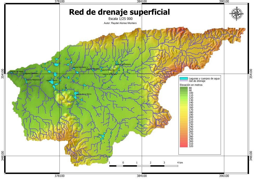
The upper endorheic part of the Almendares-Vento basin is one of the most important hydrological and karst regions in Cuba, since it contains most of the main subway recharge routes to the Vento aquifer, the main source of drinking water supply to the Cuban capital. As part of the research projects that the Institute of Geology and Paleontology carries out in the different sub-basins of the Almendares river basin, the study of this upper endorheic sub-basin was carried out, introducing for the first time the geomorphological study and its cartographic representation for this sector at a detailed scale 1/25 000, which reviews from the chronomorphogenetic point of view the complex of types and forms of the relief of the territory, taking as a basis the survey of the old Havana provinces realized of Portela. Thus, it offers the classification of the surfaces by relief category, altitudinal floor, endogenous genesis of the orographic units; as well as the analysis of the active morphostructures of the original relief and the modified lithostructures, their forms of expression, the exogenous processes that gave rise to the present relief and the ages of the surfaces. This work is therefore a useful tool in the geoenvironmental study of the Almendares-Vento basin and specifically of its upper part, and it is expected to serve as a first step to extend this type of survey to the entire general hydrological unit, with a view to carrying out deeper and more advanced geomorphological and hydrological studies of the karst.
Article Details

This work is licensed under a Creative Commons Attribution-NonCommercial 4.0 International License.
Those authors who have publications with this journal accept the following terms of the License Attribution-NonCommercial 4.0 International (CC BY-NC 4.0):
You are free to:
- Share — copy and redistribute the material in any medium or format
- Adapt — remix, transform, and build upon the material
The licensor cannot revoke these freedoms as long as you follow the license terms.
Under the following terms:
- Attribution — You must give appropriate credit, provide a link to the license, and indicate if changes were made. You may do so in any reasonable manner, but not in any way that suggests the licensor endorses you or your use.
- NonCommercial — You may not use the material for commercial purposes.
- No additional restrictions — You may not apply legal terms or technological measures that legally restrict others from doing anything the license permits.
The journal is not responsible for the opinions and concepts expressed in the works, they are the sole responsibility of the authors. The Editor, with the assistance of the Editorial Committee, reserves the right to suggest or request advisable or necessary modifications. They are accepted to publish original scientific papers, research results of interest that have not been published or sent to another journal for the same purpose.
The mention of trademarks of equipment, instruments or specific materials is for identification purposes, and there is no promotional commitment in relation to them, neither by the authors nor by the publisher.
How to Cite
References
Acevedo, M. (1989): Regionalización Geomorfológica. Nuevo Atlas Nacional de Cuba (1989). Sección IV. Relieve (12). Instituto Cubano de Geodesia y Cartografía.
Instituto de Geología y Paleontología (2014): Léxico Estratigráfico de Cuba. Editorial CNDIG. La Habana. ISBN. 978-959-7117-58-2.
Gutiérrez, M. R., Rivero, M. (1999): Regiones Naturales de la Isla de Cuba. La Habana. Editorial Científico-Técnica: pp. 27-31.
Equipo de desarrollo de QGIS. Sistema de Información Geográfica QGIS (versión 3.10 A Coruña). Software.2020. https://qgis.org/en/site
Magaz, A. G. (2017a): Geomorfología de Cuba. Amazon Books. Kindley Editions: pp- 32- 149.
Magaz, A. G. (2017b): Fallas activas. Cubageográfica (8) 4-8 julio-diciembre:
Magaz, A. G. (2018): Urbanización y Karst en La Habana. Cubageográfica. 3(6) 4-5. enero-junio
Molerio-León, L.F., Pin, M., Guerra, M.G. (2007): Diseño de la red de monitoreo de tritio en las aguas subterráneas de la cuenca de Vento. Habana, Cuba. Mapping Interactivo, Revista internacional de Ciencias de la Tierra. octubre-noviembre: 1-6
Molerio-León, L.F (2020): Los Sistemas de drenaje de la parte oriental del Karst de Escaleras de Jaruco. Cuba. Gota a gota. No.20. Sección Espeleología: 93-95
Portela, P.A., Barrios, F.A., del Busto, R., San Martin, E., Magaz, A. G., Tejeda,M. , Seco, R. (1987): Mapa Geomorfológico de las provincias La Habana y Ciudad de La Habana a escala 1: 250 000. Instituto Cubano de Geodesia y Cartografía.